Data Acquisition and Integration in GIS
Offered by Department of Earth, Environmental and Geospatial Sciences at Lehman College
Lecture 1. Introduction to Geospatial Technologies
================================================================
Introduction:
http://geospatialrevolution.psu.edu/episode1/complete
Why study geospatial technology?
https://ny.pbslearningmedia.org/resource/psu10sci.vid.geospatial.whystudy/why-study-gis-geospatial-revolution/#.WMQ3J28rLxl
================================================================
Geospatial Technology definition:
Set of tools for mapping and data analysis related to the Earth, including atmosphere, hydrosphere, biosphere and noosphere.
These tools can be grouped into four main categories:
-
GPS: global positioning systems
-
Remote Sensing: observations of the Earth from space
-
Geographic Information Systems: manipulation, analysis and visualization of geographic data
-
Internet Mapping and Analysis: interactive integration of GPS, Remote Sensing and GIS data over the Internet.
Additional References:
https://www.aaas.org/content/what-are-geospatial-technologies#about
https://www.aaas.org/page/geospatial-technologies-project
================================================================
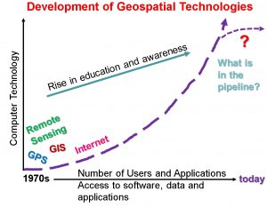
Historical Development of Geospatial Technologies in 20-21 Century:
Geospatial Technologies would not be possible without the development of computer industry since 1970s, but many principles and functions in these tools were used and developed more than 3,000 years. For example, geometric measurements and algebraic computations were known in Ancient world of Egypt and Asia. Earth measurements were conducted by Eratosthenes in 150s BCE, revolutionary geographic principles of navigation were in use in 18th and 19th centuries during great geographic discoveries. But only in 20 century computer technology allowed geospatial technologies to become what they are today.
Additional References:
Berry, J. 2007. A Multifaceted GIS Community, GEOWorld, January, 20 (1),16
================================================================
Geotechnology Development Challenges:
Two major challenges of geotechnology:
-
People are knowledgeable in their discipline but lack an understanding of geotechnology;
-
People understand geotechnology but do not know how to apply it in their discipline.
================================================================
Jobs in the Geospatial Field:
GIS Jobs Clearinghouse: www.gjc.org
GIS Jobs: www.gisjobs.com
Geosearch: www.geosearch.com
Geocommunity GIS: http://careers.geocomm.com
GIS Careers: http://giscareers.com
Geotechnology Salaries:
https://www.sokanu.com/careers/geospatial-information-scientist/salary/
================================================================
Geotechnology as a Core Tool:
https://ny.pbslearningmedia.org/resource/psu10sci.vid.geospatial.politicalaspects/geospatial-revolution-political-aspects/#.WMRjW28rJ9M
https://ny.pbslearningmedia.org/resource/psu10sci.vid.geospatial.monitorcon/geospatial-revolution-gis-to-monitor-areas-of-conflict-geospatial-revolution-episode-3/#.WMRjlG8rJ9M
https://ny.pbslearningmedia.org/resource/psu10sci.vid.geospatial.portland/geospatial-revolution-portland-an-interactive-city/#.WMRj2W8rJ9M
Additional References:
http://www.bloomberg.com/news/features/2015-07-08/satellite-images-show-economies-growing-and-shrinking-in-real-time
================================================================
Geotechnology: competency model
Knowledge:
Geography, Computer (hardware, software), English Language (read, write), Mathematics (algebra, statistics, arithmetic, calculus, etc.), Use of Training and Educational materials.
Skills:
Reading, listening, understanding scientific information, writing, problem solving, critical thinking, speaking
Abilities:
Written and oral comprehension, oral expression, deductive and inductive reasoning, near vision, written expression.
Additional References:
https://www.onetonline.org/link/summary/15-1199.05
================================================================

This entry is licensed under a Creative Commons Attribution-NonCommercial-ShareAlike 4.0 International license.

Unless otherwise noted, this work is licensed under a Creative Commons Attribution-NonCommercial-ShareAlike 4.0 International License.
© 2025 Data Acquisition and Integration in GIS.
Powered by WordPress. Designed by ![]()